

Wayanad Landslide Risk: Causes, ISRO’s Landslide Atlas, and Safety Measures
Introduction: The Urgent Need for Landslide Awareness
Wayanad, a picturesque district in Kerala, is highly vulnerable to landslides, a recurring natural disaster that threatens lives, property, and the region’s ecological balance. The recent landslide on July 30th further highlights the urgency of addressing this issue. With data from ISRO’s Landslide Atlas and insights into risk mitigation strategies, this guide provides an in-depth look at Wayanad’s susceptibility to landslides and the measures necessary for better preparedness.
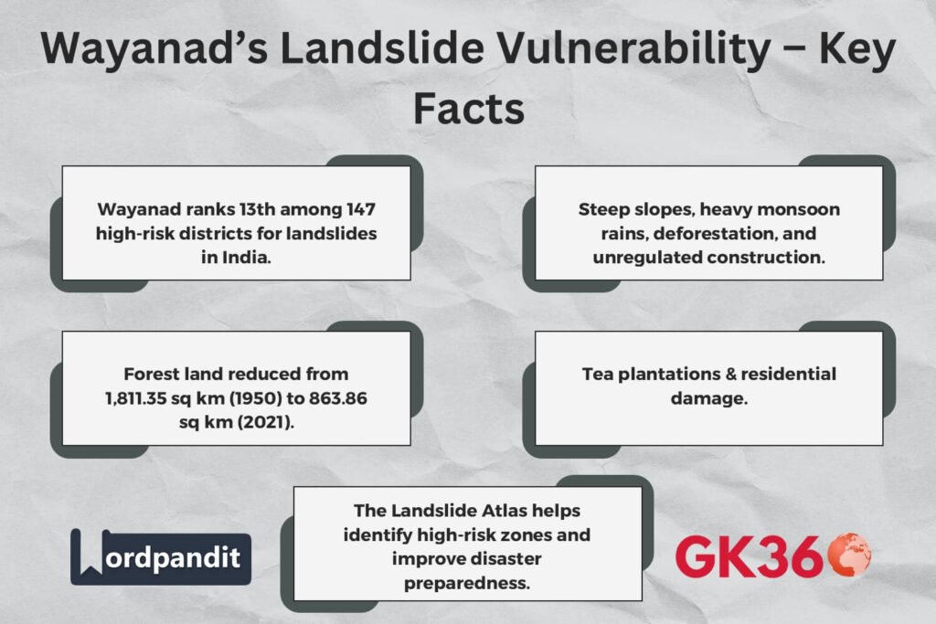
Table of Contents
- Understanding Wayanad’s Landslide Susceptibility
- The ISRO Landslide Atlas: A Key Resource
- The Role of Forest Fragmentation in Increasing Landslides
- Major Landslide Events in Wayanad
- ISRO’s Disaster Management Support: A Proactive Approach
- Key Strategies for Landslide Risk Mitigation
- FAQs
- Conclusion: Strengthening Wayanad’s Resilience
Understanding Wayanad’s Landslide Susceptibility
Wayanad’s topography, high rainfall, and deforestation make it particularly prone to landslides. The combination of steep slopes, loose soil, and monsoon downpours creates ideal conditions for soil erosion and slope failure. Rapid urbanization and unregulated construction further exacerbate the situation, leading to increased landslide occurrences.
The ISRO Landslide Atlas: A Key Resource
The Indian Space Research Organisation (ISRO) has compiled the Landslide Atlas of India, which categorizes landslide-prone areas based on historical data and satellite monitoring.
- Wayanad’s Ranking: It ranks 13th among 147 high-risk districts across 17 states and two Union Territories.
- Other High-Risk Districts in Kerala:
- Thrissur – 3rd
- Palakkad – 5th
- Malappuram – 7th
- Kozhikode – 10th
The Role of Forest Fragmentation in Increasing Landslides
Forest cover plays a crucial role in soil retention and slope stability. However, a report by the Comptroller and Auditor General of India (CAG) highlights a significant decline in Wayanad’s forest area:
- In 1950: 1,811.35 sq km of forest land
- In 2021: 863.86 sq km of forest land
- Causes: Expansion of plantation areas and urban encroachment
- Consequences: Increased soil erosion, higher landslide risks, and disruption of the region’s ecological balance
Major Landslide Events in Wayanad
ISRO’s landslide inventory (1998–2022) documents seasonal, event-based, and route-wise landslides in Wayanad. Some notable incidents include:
- 2019 Meppadi Landslide: Devastated tea plantations and residential areas.
- 2021 Puthumala Landslide: Caused significant casualties and destruction.
- 2023 Banasura Hill Landslide: Led to extensive damage due to heavy monsoon rains.
ISRO’s Disaster Management Support: A Proactive Approach
ISRO has taken active measures through its Disaster Management Support (DMS) initiative:
- Objective: Provide real-time satellite data to predict and mitigate landslide risks.
- Technological Contributions: High-resolution imaging for early warning systems.
- ISRO Chairman’s Perspective: S. Somanath emphasizes the need for integrating technology with disaster preparedness.
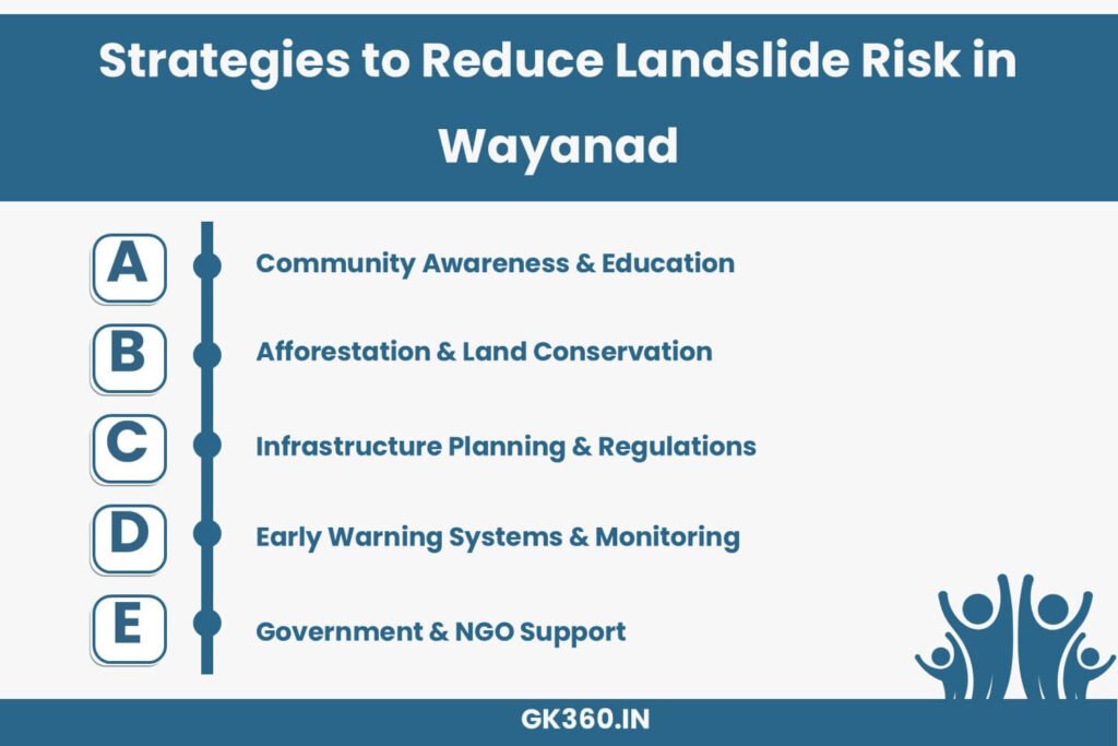
Key Strategies for Landslide Risk Mitigation
Reducing Wayanad’s landslide risk requires a multi-faceted approach:
Community Awareness & Education
- Conducting workshops for residents on landslide preparedness
- Training communities in emergency response measures
Afforestation & Land Conservation
- Implementing large-scale reforestation programs
- Promoting sustainable agricultural practices to prevent soil erosion
Infrastructure Planning & Regulations
- Enforcing construction guidelines to prevent building on unstable slopes
- Developing landslide-resistant roads and housing projects
Early Warning Systems & Monitoring
- Expanding the use of satellite-based landslide prediction models
- Installing real-time sensors in high-risk areas
Government & NGO Initiatives
- Strengthening disaster response teams
- Offering financial aid for landslide victims and rehabilitation programs
FAQs
- What are the primary causes of landslides in Wayanad?
Heavy monsoon rainfall, deforestation, soil erosion, and unregulated construction. - How does ISRO’s Landslide Atlas help in disaster preparedness?
It provides real-time data and identifies high-risk zones for better preventive planning. - What steps can residents take to protect their homes?
Avoid construction on steep slopes, plant trees, and stay informed about early warnings. - How do afforestation efforts reduce landslide risks?
Trees stabilize soil and reduce erosion, preventing slope failures. - Are there government relief programs for landslide victims?
Yes, disaster relief funds and rehabilitation programs are available through Kerala’s disaster management authority.
Conclusion: Strengthening Wayanad’s Resilience
Tackling landslide risks in Wayanad requires collaboration between government agencies, scientific institutions, and local communities. By leveraging resources like ISRO’s Landslide Atlas and implementing proactive measures, Wayanad can become more resilient against future disasters.
Key Takeaways Table
| Aspect | Details |
|---|---|
| High-Risk Location | Wayanad ranks 13th among India’s landslide-prone districts. |
| Primary Causes | Heavy monsoon rainfall, deforestation, urbanization, and soil erosion. |
| Forest Cover Decline | Lost over 52% of its forest area since 1950, increasing landslide risk. |
| Major Past Landslides | 2019 Meppadi, 2021 Puthumala, 2023 Banasura Hill – caused severe destruction. |
| ISRO’s Role | Landslide Atlas provides real-time monitoring & early warnings. |
| Prevention Measures | Afforestation, construction regulations, early warning systems, and community education. |
| Government Actions | Disaster relief funds, monitoring programs, and response training. |
Related terms
- Wayanad Landslide Risk
- ISRO Landslide Atlas India
- Kerala Landslide Disaster
- Causes of Landslides in Wayanad
- Landslide Early Warning Systems
- Deforestation and Landslides
- Disaster Preparedness in Kerala
- Wayanad Rainfall and Soil Erosion
- Environmental Conservation in Kerala
- Government Policies on Landslides


